We are Collaborative creators
We are Roto Flight
Roto Flight excels in drone technology and videography, expertly merging storytelling with cutting-edge tech solutions. Our aerial photography, videography, and 3D mapping skills have established us as key players in the film and real estate sectors. We are dedicated to combining narrative excellence with technical prowess, setting us apart as pioneers in producing visually stunning and technically advanced content. Our team embodies a blend of creativity and technical expertise, continually innovating in visual content creation.

Collaboration at Our Core: At Roto Flight, we believe in the synergy of teamwork. When you partner with us, you’re engaging with a whole team dedicated to turning your vision into an exceptional reality. Our professionals work in unison, ensuring your project benefits from a breadth of expertise and creativity.
Beyond Drones – A World of Storytelling: While we excel in aerial cinematography, our prowess extends to all facets of film and commercial production. Whether it’s crafting compelling narratives for advertisements, creating stunning visuals for films, or producing captivating commercials, we are committed to delivering excellence.
Your Vision, Our Canvas: Our mission is to blend cutting-edge technology with timeless storytelling, bringing your ideas to life with precision and creativity. At Roto Flight, we don’t just complete projects; we create experiences that leave a lasting impact.
Meet the team

Cyprian Lewicki
Co-founder & Chief Technical Officer
Cyprian is a visionary filmmaker and drone technologist passionate about capturing the world from unique perspectives. As a freelance videographer since 2020, he has successfully served numerous clients, enhancing their visual content with high-quality video, photography, and 3D tours.
His expertise is rooted in a deep technical background that includes designing and building custom drones, proficiency with Adobe Premiere, and a hands-on understanding of engineering principles. This unique blend of artistic vision and technical skill is the driving force behind the company’s innovative production style.

JONNY ANDERSON
Co-founder & Chief Marketing Officer
Jonny is a seasoned business development and marketing strategist with a proven track record of building brands and driving significant sales growth. As PR/Marketing Manager for RebuffReality.com, he established key industry relationships, including with Meta and HTC Vive.
His previous experience as a founder of Shed Studio saw him direct over 100+ marketing projects for B2B clients, demonstrating his ability to attract high-value clients and lead creative teams. As the primary host and head of social media, his expertise will drive brand growth and audience engagement.

Sierra GOrdon
Videographer & Photographer
Sierra Gordon is a passionate videographer and photographer with a keen eye for capturing authentic moments. Her work is marked by dynamic shots and emotional depth, blending technical expertise with artistic vision to bring compelling stories to life on screen. She is a film production student at Santa Barbara City College and President of the SBCC Film Community Club.

Shay Lyon
Video Editor
A skilled editor and videographer and a California Polytechnic University alumnus, Shay has honed his craft through media studies and hands-on experience across narrative, commercial, and social media projects. He brings strong editing, audio, and camera skills to every stage of the production process.

Tary McCullough
Video Editor
With 14 years of experience in video editing and graphic design, Tary has mastered Adobe software to create captivating visual content. As a post-production manager, he collaborates with editors to ensure projects are professionally executed and tell compelling stories. His diverse portfolio highlights his commitment to high-quality results, thriving in dynamic environments to bring clients’ visions to life.
Frequently Asked Question
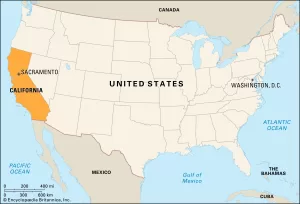
Our operations are intensified throughout California. Emphasizing that Southern California is closest to us as it is our current home!
But we also operate throughout the United States, especially for larger orders such as large commercial facilities (hotels, factories, large warehouse spaces).
Typically, once the shoot is completed, you can expect your edited photos and videos within 24-48h. However, for more complex projects the turnaround time might take up to 72h.
Weather can be unpredictable. If conditions are not suitable for flying, we’ll reschedule the operation to a more suitable day at no additional cost to you.
In most cases, as the property owner, you have the right to authorize drone flights over your property. However, we always ensure that our operations comply with local and federal regulations. If any additional permissions are needed, we’ll guide you through the process.
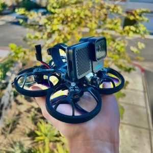
We have drones for both inside and outside use. Our indoor drones are small, light, and can fit in your hand. They’re great for showing the inside of buildings, which is becoming popular in the business of selling properties.
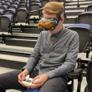
Our drone pilots are skilled and have the right licenses. They wear special goggles to see what the drone sees, making it easy to fly the drone through rooms without any problems.
Frequently Asked Question
Most often asked
We have drones for both inside and outside use. Our indoor drones are small, light, and can fit in your hand. They’re great for showing the inside of buildings, which is becoming popular in the business of selling properties.
Our drone pilots are skilled and have the right licenses. They wear special goggles to see what the drone sees, making it easy to fly the drone through rooms without any problems.
Our operations are intensified throughout California. Emphasizing that Southern California is closest to us as it is our current home!
But we also operate throughout the United States, especially for larger orders such as large commercial facilities (hotels, factories, large warehouse spaces).
Typically, once the shoot is completed, you can expect your edited photos and videos within 1-2 business days. However, for more complex projects like 3D mapping or virtual tours, the turnaround time might take 2-5 days.