INDUSTRIAL DRONE SOLUTIONS THAT MAKE THE WORLD MORE PRODUCTIVE AND SAFE

Drone-based aerial mapping provides solutions in diverse areas: inspecting infrastructure for maintenance issues, mapping construction sites for better project planning, and monitoring crop health in agriculture, enhancing efficiency, precision, and safety, while significantly reducing operational costs.

Inspection

Power LinesBridgesWind Turbines

Inspecting infrastructures such as power lines, wind turbines, and oil pipelines. Identifying potential issues, helping to prevent problems.

Construction

Creating MapsProgress TrackingShowcasing

Generating topographic maps for site planning, monitoring construction status, showcasing properties, and conducting land surveys.

Agriculture

Crop's healthAnalyzing Soil

Monitoring crop health, analyzing soil, precision agriculture, optimizing irrigation, and effectively managing pest strategies.

Thermal

InspectionsEnergy leaks

Inspecting infrastructure, tracking wildlife. Helping to save energy and minimize maintenance. Environmental monitoring and conservation.

The Benefits of Aerial Mapping with Drones

Increased Accuaracy

Drones equipped with sophisticated cameras and sensors can capture high-resolution imagery and topographical data with incredible precision.

Safer Data Collection

Utilizing drones, we have the capability to explore inaccessible or potentially dangerous regions, ensuring human safety by avoiding the direct exposure to such risks.

Time And COst Efficiency

Drones, as opposed to traditional, costly manned flights, provide a swifter, cost-effective method for accomplishing aerial mapping projects more efficiently.

Environmentaly Friendly

Battery-operated drones minimize the carbon footprint, offering a more environmentally-friendly alternative to traditional aerial surveying methods.

Monitor your construction sites as they evolve!

In construction projects, drones are instrumental in providing quick, accurate and regular progress updates, enhancing overall project efficiency and decision-making. By conducting routine aerial surveillance, drones can detect and report potential issues early, averting major construction delays and associated costs.

Use middle slider to see progress:
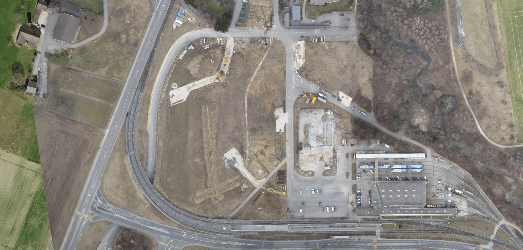
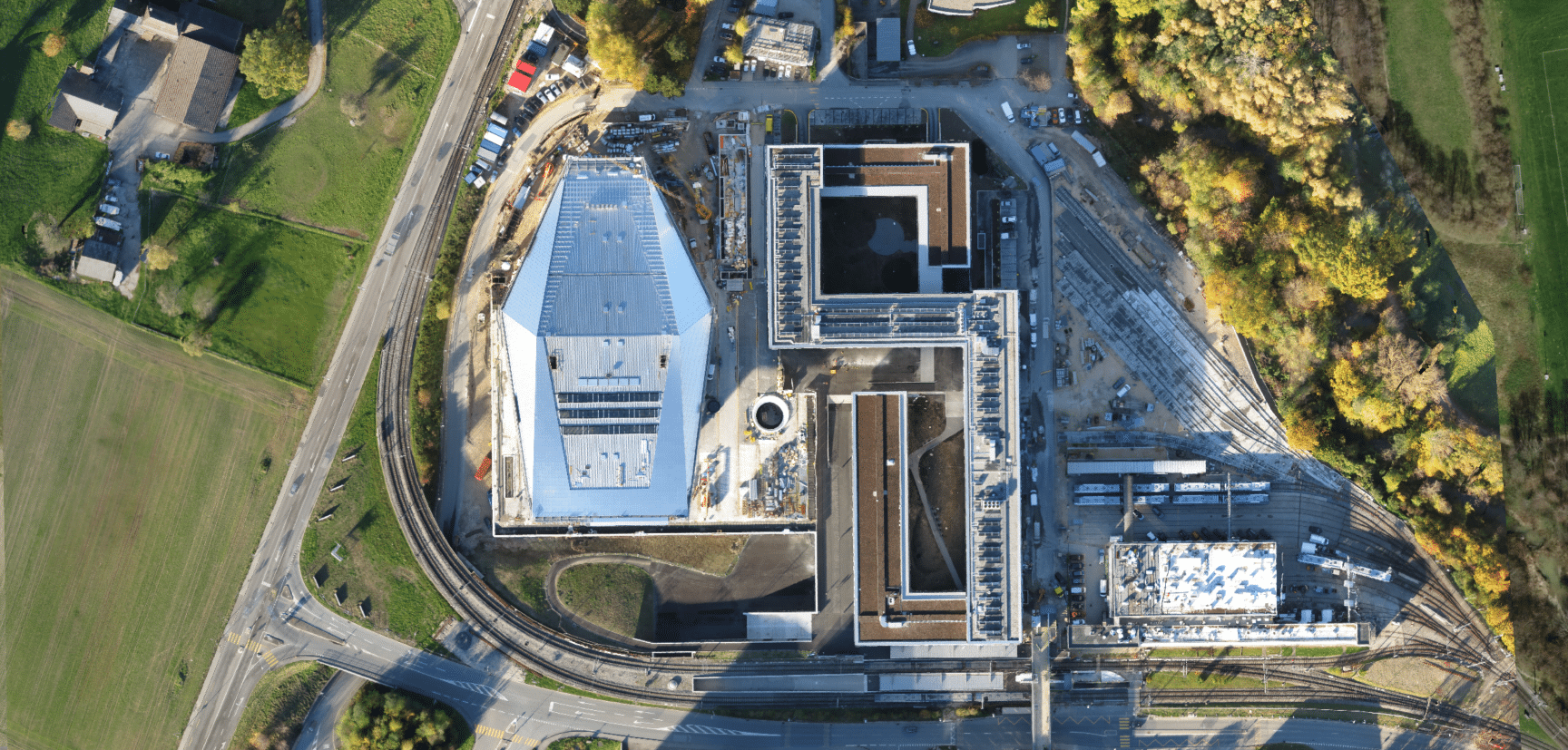
February 2011March 2014

Site Models

2D Orthomosaic

Discover the power of 2D orthomosaics with our high-resolution, geometrically accurate imagery. Ideal for various applications from urban planning to agriculture, our services provide detailed insights and integrate seamlessly with GIS systems. Contact us today to explore tailored solutions for your landscape needs.

3D Model

Unlock the potential of 3D photogrammetric – Ideal for various applications from urban development to environmental analysis, our 3D models provide exceptional detail and accuracy. Seamlessly integrate our models with existing systems for a comprehensive project view. Contact us today to explore tailored solutions.

DSM – Digital Surface Model

Explore the precision of our Digital Surface Models (DSM), where topography meets technology. Ideal for applications ranging from urban planning to environmental monitoring, our DSM provides an accurate representation of the surface features. Gain insights into elevation, terrain, and more with our high-resolution models. Contact us today to discover tailored solutions that fit your landscape analysis needs.

Agriculture Multispectral

Discover advanced farming with our multispectral drone data collection. Our technology offers detailed insights into crop health and soil conditions, enhancing yield and resource conservation. Ideal for proactive pest management and plant analysis, our high-precision approach nurtures agricultural efficiency. Contact us for customized farming solutions tailored to your unique needs.

DATA OUTPUTS

DATA FLOWCHART

AVAILABLE OUTPUTS

The potential applications of aerial data gathered by Roto Flight are vast and varied. Some methods are geared toward engaging presentations and promotional content, while others focus on critical aspects of your business operations.

Your final vision will dictate the types of output formats you can choose from. Images from job sites might be categorized for internal purposes, while other visual formats might be designed for public viewing and effortlessly integrated into your company’s website. Here’s an overview of the formats Roto Flight can provide:

  • GeoTiffs – 2D: Map-like images
  • Full-sized JPEGs – 2D: High-resolution pictures
  • DEM (Digital Elevation Model) – 2D: Terrain representations
  • NDVI – 2D: Tools to analyze vegetation health
  • Google Earth KMZ in 3D
  • Point Cloud LAS in 3D
  • OBJ Files in 3D
  • Various Other 3D Outputs: Including PLY, FBX, DXF, and more.

How Does it Work?

In 4 EASY STEPS

1. GET STARTED

Write to us detailing the service you’re interested in or the outcome you want to achieve with our drone services.

2. DISCUSS DETAILS

After receiving your request, we’ll reach out to clarify specifics. Then, choose a date for the service, and we’ll schedule it.

3. Mission Execution

Our team will visit your location, plan the drone flight, and capture the content. You’ll be impressed by our pilot skills!

4.Delivery

Each client gets personal cloud storage. After the project, you’ll get a link to access and use your content as needed.

Reach out

Got a question or an idea you would like to share? Please leave your information down below and we will reach back within few hours. You can also call us (DAILY, 10am-5pm) at (805) 699-6282.

Why choose Roto Flight?

Frequently Asked Question

General

Safety is our top priority. We conduct thorough pre-flight checks, risk assessments, and always adhere to FAA regulations. Our pilots are trained to handle emergencies and are always in communication with ground teams during operations.

In most cases, as the property owner, you have the right to authorize drone flights over your property. However, we always ensure that our operations comply with local and federal regulations. If any additional permissions are needed, we’ll guide you through the process.

The cost varies based on the complexity and duration of the project. Please contact us with your specific requirements, and we’ll provide a detailed quote.

Weather can be unpredictable. If conditions are not suitable for flying, we’ll reschedule the operation to a more suitable day at no additional cost to you.

Industrial Data Collection

Our drones are equipped with state-of-the-art sensors and cameras, ensuring data accuracy up to 99%. For tasks requiring extreme precision, we employ RTK (Real-Time Kinematic) drones that provide centimeter-level accuracy.

A wide range of industries can benefit, including agriculture, construction, environmental monitoring, and more. Our drones can capture detailed data for site analysis, crop health monitoring, and other specific needs.

Our drones are equipped with a variety of sensors, including high-resolution RGB cameras, multispectral sensors, thermal cameras, and LIDAR. The choice of sensor depends on the specific requirements of the project.

Yes, our drones are capable of covering large areas efficiently. Depending on the project’s requirements, we can deploy drones with longer flight times or use multiple drones to ensure comprehensive coverage. We can cover up to 1,500 acres per day.

Once data is collected, it undergoes processing using specialized software. The final output can be in the form of detailed maps, 3D models, orthomosaics, or specific data sets, depending on the project’s requirements. We ensure the data is easily accessible and interpretable for our clients.

Absolutely! We can schedule regular drone flights over your site to monitor changes over time. This is particularly useful for projects like construction progress tracking, environmental monitoring, or observing seasonal changes in agriculture.

Data security is paramount to us. All collected data is encrypted and stored securely. We also offer cloud storage solutions with restricted access to ensure your data remains confidential and safe.

Yes, our drones are designed to operate in a variety of terrains and conditions, from mountainous regions to dense forests. We always conduct a thorough pre-flight assessment to ensure safe and efficient data collection.

*Disclaimer

Roto Flight is proficient in collecting aerial data, but it’s essential to understand that we don’t process survey-grade information. If your project requires precise measurements, it’s crucial to consult a licensed land surveyor or survey engineer. While Roto Flight can collaborate with your surveyor to provide data, our services don’t negate the need for a licensed land surveyor in any jurisdiction. This limitation isn’t unique to us; any drone data collection service without a surveyor on board cannot interpret such data. Furthermore, we refrain from superimposing property boundaries on residential plots, whether developed or undeveloped, for the aforementioned reasons.

EXPLORE OTHER SERVICES

Chair set against a window, featured in the Real Estate Media section of Roto Flight's company imagery.

REAL ESTATE MEDIA

Promoting properties through visuals, content, and communication, aiding sales, rentals, and engagement. Ultimate virtual experience for exploring any type of estate and providing it to:

Real Estate AgentsIndividual SellersRental ManagersInvestorsDevelopersArchitects and DesignersAppraisers

A person performing precision drone operations, riding a mountain bike in the air.

Precision Operations

Executing precise FPV flights. We produce captivating content for all industries. Offering the best virtual exploration experience for diverse applications and audiences:

BusinessesOffice Spaces RestaurantsHotels / SpasWarehousesFront StoresMuseumsVenuesHealthcare facilitiesConcert hallsGolf CoursesundefinedCinema